World-class training for the modern energy industry

Hydrogen Technology: Value Chain and Projects (G572)

Tutor(s)

Matthew Healey: Managing Director, PACE CCS.

Overview

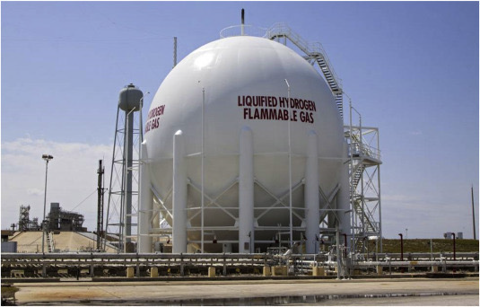
This course is designed to provide the participants with a summary of the technical and engineering challenges within hydrogen energy, including production, storage and transport, in addition to associated risk and safety challenges.

Duration and Logistics

Classroom version: A 1-day in-person classroom course. An electronic copy of the manual will be provided by the tutor at the end of the course.

Virtual version: Two 3.5-hour interactive online sessions presented over 2 days, including a mix of lectures and discussion. The course manual will be provided in digital format.

Level and Audience

Advanced. This course is designed for all technical staff working on hydrogen projects with an emphasis on operations, facilities and engineering aspects.

Objectives

You will learn to:

  1. Outline the different ‘colours’ of hydrogen and how these are produced.
  2. Evaluate the technical challenges with hydrogen, including thermodynamic modelling of H2 mixtures.
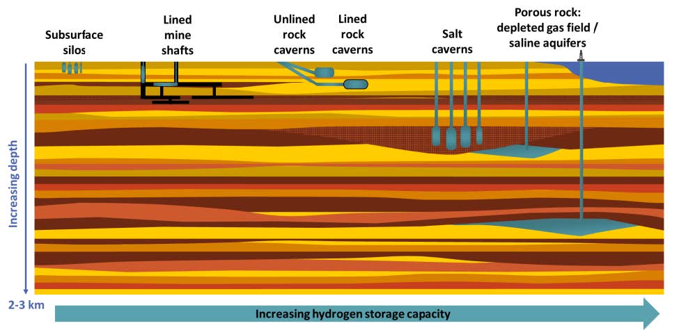
  3. Review how H2 can be stored and transported safely.
  4. Outline the design specifications of H2 networks with a focus on pipelines, including material of construction and reuse of existing infrastructure.

Salt Tectonics – From Concepts to Application (G020)

Tutor(s)

Mark Rowan: President, Rowan Consulting, Inc.

Overview

This course covers all aspects of global salt tectonics. It discusses the origin and nature of evaporite basins and provides instruction on the essential elements of salt mechanics, diapirism, salt-related structural styles and salt-sediment interaction. Covered material ranges from fundamental concepts and practical application, to the influence of salt on petroleum systems. Lectures are complemented by exercises interpreting a variety of seismic data, illustrating characteristic structural styles and evolutionary development of salt basins.

Duration and Logistics

Classroom version: A 4-day classroom course comprising a mix of lectures (75%) and seismic exercises (25%). The manual will be provided in digital format and participants will be required to bring a laptop or tablet computer to follow the lectures and exercises.

Virtual version: Eight 3-hour interactive online sessions presented over 8 days. A digital manual and exercise materials will be distributed to participants before the course. Some reading and several exercises are to be completed by participants off-line.

Level and Audience

Advanced. The course is intended for geoscientists who wish to strengthen their skills in evaluating salt basins around the world.

Objectives

You will learn to:

  1. Understand the implications of layered-evaporite sequences for velocity-model building and seismic interpretation.
  2. Describe how halite differs from other lithologies and how that impacts deformation in salt basins.
  3. Characterize the ways in which extension, contraction and differential loading trigger salt flow and diapir initiation / growth.
  4. Evaluate how salt impacts deformation in different tectonic environments, including rift basins, divergent margins and convergent-margin fold-and-thrust belts.
  5. Interpret typical salt and stratal geometries associated with salt evacuation and diapirism.
  6. Predict how drape folding around passive diapirs impacts stratal geometries, faulting and reservoir distribution in diapir-flank traps.
  7. Understand why and how allochthonous salt forms and how salt sheets / canopies evolve.
  8. Assess the effects of salt on various aspects of the petroleum system, including trap formation, reservoir presence and quality, hydrocarbon maturation and migration, and weld seal.

Modeling and Development Planning in Carbonate Reservoirs, Provence, France (G034)

Tutor(s)

Mark Bentley: TRACS International Consultancy and Langdale Geoscience.

Overview

Using analogue outcrops in the Luberon and Cassis area of southern France, this course develops workflows for static and dynamic modeling in carbonate reservoirs, covering in particular the issues of conceptual reservoir characterization, the handling of scale and the representation of fracture detail in cellular models. The analogue section chosen is a direct analogue for Shuaiba/Kharaib Middle East reservoirs, including high and low energy areas of rudist platforms, inner and outer shelves, and chalks. The modeling principles are transferable to other carbonate environments.

Duration and Logistics

7 days; field activities and exercises (100%); the outdoors will be used as a classroom.

Level and Audience

Advanced. A course for technical professionals working in integrated teams who are planning development activities in carbonate reservoirs (reservoir engineers, geoscientists, petrophysicists) and all involved in reservoir and simulation modeling.

Exertion Level

This class requires an EASY exertion level. Provence is quite comfortable in the late summer to fall, with temperatures of 10-25°C (50-80°F) and occasional rain showers. The field locations are all easily accessible requiring only a short walk from the transport. The longest walk is approximately 0.5km (0.3 mile) along a road section. There will be one boat trip (weather dependent) to view key cliff exposures that can only be seen from offshore (1-2 hours duration).

Objectives

You will learn to:

  1. Describe a carbonate reservoir in terms of essential reservoir elements and the architectural arrangement of those elements.
  2. Evaluate reservoir property distributions for those elements in a form suitable for input to static/dynamic reservoir modeling.
  3. Judge the scale at which a static/dynamic modeling exercise should be conducted, including any need for multi-scale modeling.
  4. Prepare rules of thumb for effective property modeling in carbonates at a range of scales.
  5. Assess fracture systems in carbonates and explain the options for modeling them (explicit DFN vs implicit effective properties).
  6. Apply the concept of representative elementary volumes (REV) to fractured and unfractured carbonates.
  7. Discuss optimal development planning for an oil reservoir based on the outcrops seen during the course.
  8. Catch up with current research activities in carbonate reservoirs.

Reservoir Characterization of Deepwater Systems: Ross Formation, County Clare, Ireland (G023)

Tutor(s)

Rene Jonk: Director, ACT-Geo Consulting and Training; Honorary Professor, University of Aberdeen.

Overview

Given the high cost of exploration and development of deepwater reservoirs, it is essential to have an accurate pre-drill prediction of reservoir architecture and properties, and to integrate post-drill assessments of reservoir heterogeneity away from well penetrations. The outcrops of the Ross Formation offer a unique opportunity to observe seismic-scale exposures of a deepwater fan system with characteristics similar to the producing fields in West Africa, Brazil and the Gulf of Mexico, to name a few. The size and quality of the exposures allow the participants to observe the main building blocks of fan systems. Lobes and distributary channels can be observed from proximal to distal settings, with excellent exposures of vertical stacking and 2-D arrangements of these elements.

Duration and Logistics

A 7-day field course comprising a mix of field activities with exercises (60%) and classroom lectures with exercises (40%). Exercises emphasize practical applications and will focus on description of deepwater lithofacies, stratal geometries and recognizing key stratigraphic surfaces. The course is based in Kilkee Bay, Ireland, with participants flying in and out of Shannon, Ireland.

Level and Audience

Advanced. This course is intended for geoscientists, petrophysicists, engineers and managers who are seeking to gain a comprehensive understanding of deepwater reservoirs.

Exertion Level

This class requires an EASY exertion level. Access to the coastal outcrops is relatively easy and there will be walks of up to 2km (1.2 miles) most days, all at sea level. The longest walk on the class is approximately 3.2km (2 miles), with no ascent or descent over 50m (160 feet). Summer weather can be cool and wet, or warm and wet, with a daily temperature range of 4–24°C (40–74°F). Transport will be by van on paved roads.

Objectives

You will learn to:

  1. Interpret and map different archetypes of deepwater reservoirs using cores, well-logs and seismic lines, from exploration to production business scales.
  2. Define trap configurations and perform risk assessment for stratigraphic traps.
  3. Estimate reservoir presence risk and predict N:G.
  4. Interpret environments of deposition (EoDs) and related reservoir architecture, lithofacies associations and diversity.
  5. Evaluate reservoir geometry and connectivity in different EoDs, integrating with production data.
  6. Define depositional geometries of turbidites in seismic-scale outcrops.

The Transportation and Geological Storage of Hydrogen (G576)

Tutor(s)

Katriona Edlmann: Chancellor’s Fellow in Energy, The University of Edinburgh.

Overview

The course will focus on the need for geological storage of hydrogen, introducing the geological storage options available for the secure storage and withdrawal of hydrogen from these different geological stores. The main body of the course will explore the key considerations involved in geological hydrogen storage, including hydrogen flow processes and thermodynamics; geomechanical responses to rapid injection and withdrawal cycles; geochemical and microbial interactions during storage; and the operational considerations and monitoring of hydrogen storage sites that may impact storage integrity, withdrawal rates and hydrogen purity.

Duration and Logistics

Classroom version: A 1.5-day course comprising a mix of lectures, case studies and exercises. The manual will be provided in digital format and participants will be required to bring a laptop or tablet computer to follow the lectures and exercises.

Virtual version: Three 4-hour interactive online sessions presented over three days. Digital course notes and exercise materials will be distributed to participants before the course. Some exercises may be completed by participants off-line.

Level and Audience

Advanced. The course is largely aimed at geoscientists, but engineers will also find the course instructive. Intended for sub-surface scientists, with an emphasis on geoscience topics. Participants will probably have a working knowledge of petroleum geoscience.

Objectives

You will learn to:

  1. Describe the different geological storage options available and their capacity and spatial constraints.
  2. Understand hydrogen as a fluid in the subsurface, including its thermodynamic and transport properties.
  3. Characterize the geomechanical considerations for storage integrity and associated risks, including caprock sealing considerations.
  4. Appreciate the impact of geochemical and microbial interactions in subsurface hydrogen stores and the relevant monitoring and management tools.
  5. Describe the operational engineering considerations and monitoring of hydrogen storage sites.

Geochemical effects of CO2 on Reservoir, Seals and Engineered Environments during CCS (G544)

Tutor(s)

Richard Worden: Professor in the Department of Earth Ocean and Ecological Sciences, University of Liverpool, UK.

Overview

The geochemistry of saline aquifers, depleted oil/gas fields in the context of CO2, and other waste gas, injection is considered. The reactions of CO2 with different reservoir rocks and top-seals, and their constituent minerals, and the cement and metal work used in the construction of wells are central to this course. The course includes reference to numerous CCS and CO2-EOR case studies, CCS-pilot sites, experiments, geochemical modelling, reaction-transport modelling, monitoring of CCS sites, microbiological processes in CCS systems, and the risk of halite scale formation.

Duration and Logistics

Classroom version: A 3-day course comprising a mix of lectures, case studies and exercises. The manual will be provided in digital format, and participants will be required to bring a laptop or tablet computer to follow the lectures and exercises.

Virtual version: Five 3.5-hour interactive online sessions presented over 5 days. Digital course notes and exercise materials will be distributed to participants before the course. Exercises will be used throughout the course; these will include calculations, largely based on spreadsheets. Quizzes will be used to test knowledge development.

Level and Audience

Advanced. The course is largely aimed at specialist geoscientists, but petroleum engineers and petrophysicists who are working on, or plan to work on, CCS projects will also find the course instructive. A foundation knowledge of geochemistry is assumed.

Objectives

You will learn to:

  1. Appraise the types and sources of information needed to define geochemical aspects of CCS sites.
  2. Evaluate the role of CO2 pressure in influencing reactions at CCS sites.
  3. Assess the information that can be gathered from natural analogues of CCS projects.
  4. Evaluate the role of composition of the injected gas (role of contaminants) in influencing reactions at CCS sites.
  5. Gauge the role of water composition in influencing reactions at CCS sites.
  6. Characterize the role of mineral composition (rock type) in influencing reactions at CCS sites.
  7. Manage examples of mineral dissolution in CCS systems.
  8. Predict possible examples of mineral precipitation in CCS systems.
  9. Gauge CO2 interaction with cements and pipes used in well completions.
  10. Assess how experimental simulation, geochemical reaction modelling and reaction transport modelling can help predict if dissolution or precipitation will occur.
  11. Validate the links between geochemical processes and geomechanical and petrophysical properties in CCS systems.
  12. Use geochemical tracers to track process in CCS systems.
  13. Characterize the microbiological processes that may occur at CCS sites.
  14. Predict the geochemical formation damage in CCS.
  15. Quantify the role of CCS in basalt hosts in comparison to sedimentary hosts.

Seals, Containment and Risk for CCS and Hydrogen Storage (G570)

Tutor(s)

Richard Swarbrick: Manager, Swarbrick GeoPressure.

Overview

This course examines the nature and properties of seals as they relate to containment for permanent storage of CO2 and cyclical storage of hydrogen and/or compressed air. The course will provide a grounding in the geomechanics of seals and how seals and their properties are created in the subsurface. While most data and analysis relating to seals has been acquired from and applied to the containment of oil and gas, this course will show how such data can be applied to CCS and gas storage. Particular attention will be given to the different sealing requirements of CO2 and hydrogen relative to oil/gas and water.

Duration and Logistics

Classroom version: A 3-day course comprising a mix of lectures, case studies and exercises. The manual will be provided in digital format and participants will be required to bring a laptop or tablet computer to follow the lectures and exercises.

Virtual version: Five 3.5-hour interactive online sessions presented over 3 to 5 days comprising a mix of lectures and exercises. The course manual will be provided in digital format.

Level and Audience

Advanced. This course is aimed at geoscientists and engineers working in energy transition with responsibility for projects to assess and manage gas storage

Objectives

You will learn to:

  1. Evaluate the nature of containment seals and their properties in the deep earth (>1km/0.62 miles below surface).
  2. Apply knowledge of seal integrity to estimates of column heights and associated storage volumes.
  3. Assess the concepts of seal integrity and how to predict risk of seal breach/failure.
  4. Appraise current knowledge of seal behaviour using case studies.
  5. Manage the requirements for permanent CO2 storage using CCS versus short-term/cyclic storage for hydrogen air.
  6. Characterize data requirements and limitations to assess seal integrity and risk (data sourced mainly from oil/gas boreholes).
  7. Evaluate different trapping requirements for gas storage (currently data-poor) relative to oil/gas (historically data-rich).
  8. How geochemical fluid-rock reactivity may impact seals to gas storage over time.

Carbon Capture and Storage Value Chain: Network Design and Operational Technologies (G571)

Tutor(s)

Matthew Healey: Managing Director, PACE CCS.

Overview

This course is designed to provide awareness of the design and operation of CCS systems. Participants will gain knowledge and understanding of technical issues (flow assurance, process, safety, etc.) encountered in the design and operation of whole-chain CCS systems.

Duration and Logistics

Classroom version: A 2-day in-person classroom course. An electronic copy of the manual will be provided by the tutor at the end of the course.

Virtual version: Four 3.5-hour interactive online sessions presented over 4 days, including a mix of lectures and discussion. The course manual will be provided in digital format.

Level and Audience

Advanced. This course is suitable for all technical staff engaged in carbon capture and storage with an emphasis on the operations, facilities and engineering side of the business. Project managers and engineers will also find many aspects of the course useful.

Objectives

You will learn to:

  1. Compare the primary CO2 capture technologies.
  2. Review the fundamental subsurface geoscience aspects of CCS, including reservoirs, leakage and monitoring.
  3. Establish how CO2 can be transported safely and efficiently via ship and pipeline.
  4. Assess the thermodynamic behavior of CO2 including the impact of impurities in CO2 streams.
  5. Describe the operating philosophy and modes of CO2 transport networks, both single and multiphase.
  6. Outline the design specifications of CCS networks with a focus on pipelines.
  7. Manage safety and technical risk, including using a consequence-based risk assessment for CCS.
  8. Evaluate the thermal-hydraulic modelling of CO2 transport networks with a focus on best practices.
  9. Analyze the shipping options for CO2, including port to port or port to storage.
  10. Characterize CCS metering and associated technologies.

Geomodelling for CO2 Storage (G560)

Tutor(s)

Matthew Jackson: Chair in Geological Fluid Dynamics, Imperial College London.

Overview

This course provides an overview of all subsurface aspects of geomodelling relevant to CO2 storage. The course includes an introduction to the principles and practice of geomodelling; reservoir characterization for CO2 storage, including geological, geophysical and petrophysical considerations; methods used to produce 3-D geomodels; approaches to uncertainty characterization and quantification; and an overview of available software tools. The course does not provide hands-on training in these software tools, but rather provides the background understanding for software tool selection and associated training from vendor(s). The concepts and methods are illustrated using numerous practical examples of geomodelling studies.

Duration and Logistics

Classroom version: A 3-day course comprising a mix of lectures, case studies and exercises. The manual will be provided in digital format and participants will be required to bring a laptop or tablet computer to follow the lectures and exercises.

Virtual version: Five 3.5-hour interactive online sessions presented over 5 days. A digital manual and exercise materials will be distributed to participants before the course. Some reading and exercises are to be completed by participants off-line.

Level and Audience

Advanced. The course is intended for professionals with experience of, or background in, a related subsurface geoscience area and those directly working on CO2 storage projects.

Objectives

You will learn to:

  1. Characterize the underlying aims and concepts of ‘fit for purpose’ reservoir geomodelling.
  2. Prepare different types and associated applications of geomodels for CO2 storage.
  3. Validate reservoir characterization data for CO2 storage, including geology, geophysics and petrophysics.
  4. Assess methods for quantitative 3-D geomodel construction, including advantages and disadvantages of each.
  5. Manage performance metrics for geomodels.
  6. Appraise the importance of, and methods for, quantitative uncertainty assessment.
  7. Rate the different software tools used for geomodelling.
  8. Evaluate practical examples of geomodelling for CO2 storage.

Geothermal Drilling and Completion (G558)

Tutor(s)

Catalin Teodoriu: Mewbourne Chair in Petroleum Geology, The University of Oklahoma.

Overview

This course covers fundamental aspects of geothermal drilling and completion engineering, highlighting the differences between conventional oil and gas and geothermal activities. It encompasses the main geothermal drilling characteristics, focusing on deep geothermal well construction and completion concepts. The course also covers conventional and unconventional geothermal technologies, addressing the need of drilling and completion challenges. The last part of the course will concentrate on well integrity aspects, ranging from existing oil and gas wells to built-for-purpose geothermal wells.

Duration and Logistics

Classroom version: A 3-day course comprising a mix of lectures, case studies and exercises. The manual will be provided in digital format and participants will be required to bring a laptop or tablet computer to follow the lectures and exercises.

Virtual version: Five 4-hour interactive online sessions presented over 5 days. A digital manual will be distributed to participants before the course. Some reading is to be completed by participants off-line.

Level and Audience

Advanced. The course is intended for geoscientists wishing to learn the engineering aspects of geothermal project implementation, and oil and gas professionals transitioning towards sustainable energy opportunities.

Objectives

You will learn to:

  1. Identify key factors in streamlining geothermal project decision making processes.
  2. Understand different management styles and their impacts on geothermal planning and execution.
  3. Identify the uncertainties and risks associated with drilling geothermal wells.
  4. Assess the impact of different well construction and completion concepts on the life of the well integrity.
  5. Discuss and analyze case studies involving different geothermal well construction solutions.