World-class training for the modern energy industry

Structural Styles and Fault Characterization in Exploration and Production, Moab, Utah (G078)

Tutor(s)

Russell Davies: Director, Redlands Fault Geological Consulting LLC.

Overview

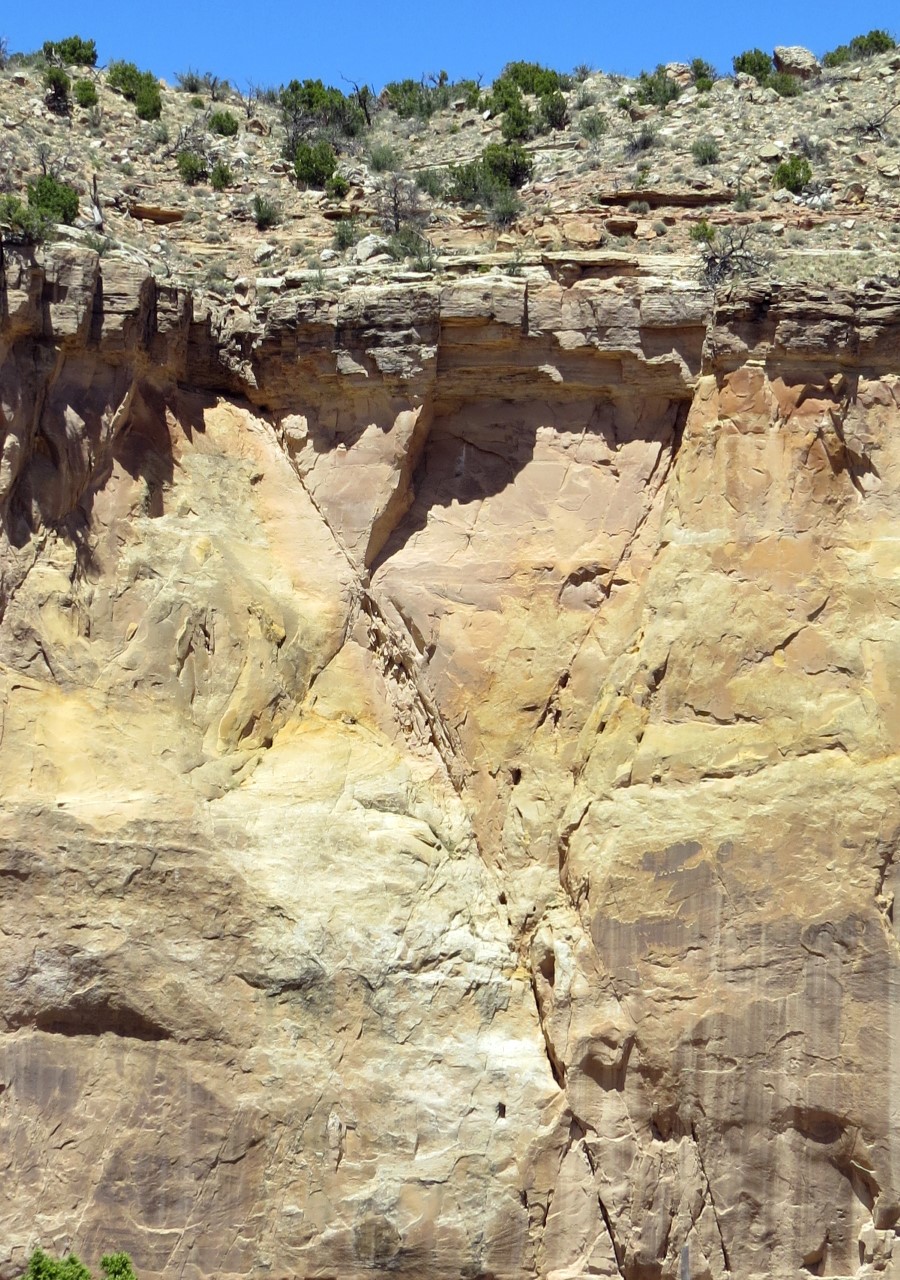
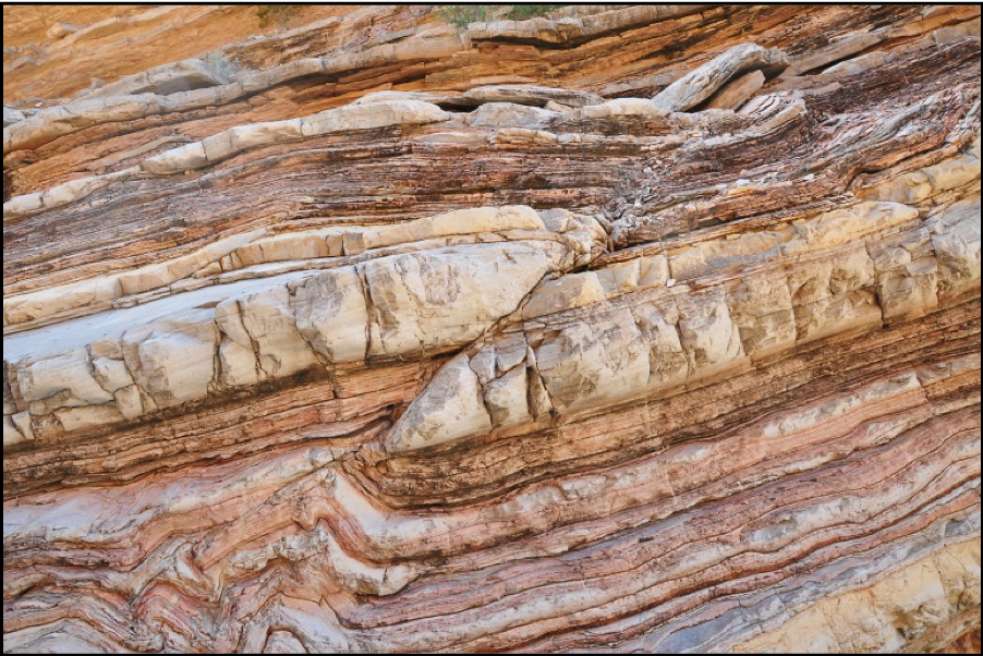
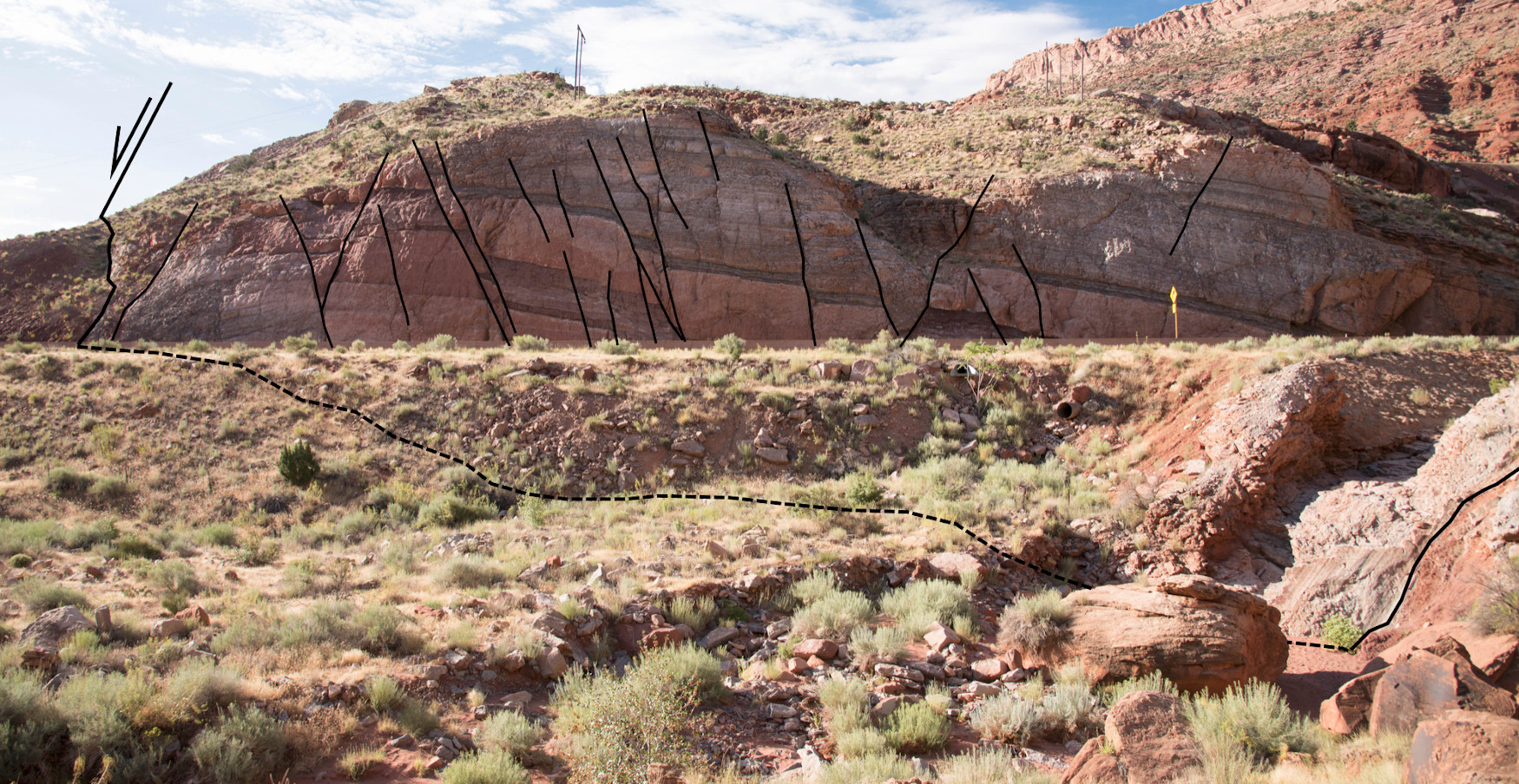
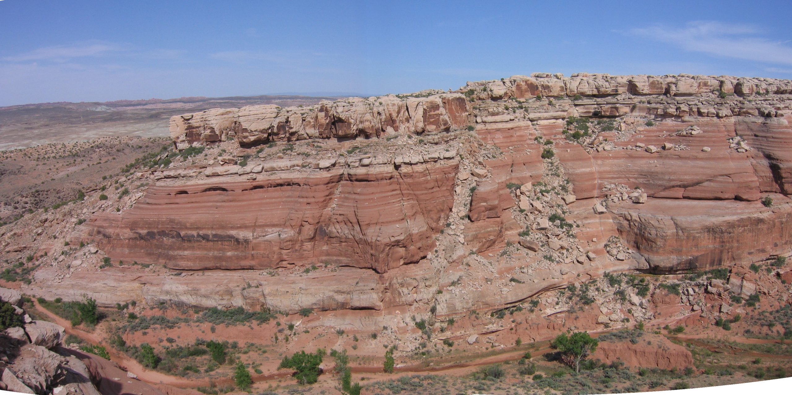
This field course utilizes outstanding exposures of faults, fault rocks and stratigraphy in Colorado and Utah to examine seismic and subseismic scale fault geometries, fault zone architecture and controls on cross-fault flow. The aim of the course is to improve the understanding of uncertainties in the mapping of complex fault zones and the processes that create potential seals and compartmentalization in reservoirs in the subsurface for oil and gas, as well as CO2. Field exercises complement classroom lectures on the interpretation of faults, seal assessment and associated risks. Group exercises are included as prospect interpretation of compartmentalization from outcrop exposures.

Duration and Logistics

A 7-day field course with a mixture of outcrop examination and discussion (70%) and supporting classroom lectures (30%). Exercises on the outcrop are designed to apply common methodologies for fault seal analysis with observed fault zone characteristics.

Level and Audience

Intermediate. This course is suitable for geologists, geophysicists and reservoir engineers engaged in the interpretation of faults and the assessment of fault seal in reservoirs for exploration, development and CO2 containment.

Exertion Level

The field component of this course requires a MODERATE exertion level. There will be some short hikes to outcrops (no more than 3.5 miles / 5.6km round trip), some over uneven and rocky ground with some short, steep inclines no greater than 700 feet (200 meters). The climate in southern Utah during the spring and fall is variable with temperatures from 50°F (10°C) to hot and dry up to 100°F (38°C). The elevation is between 4,000 and 5,000 feet (1200 to 1500 meters).

Objectives

You will learn to:

  1. Describe the regional geologic framework of the field area, the main stratigraphic units and the principal structural features.
  2. Characterize the mechanisms of faulting, fault propagation and the controls on the size, distribution and population of normal faults.
  3. Observe deformation and faults in outcrop to constrain likely structural and fault geometries in the subsurface.
  4. Characterize common trapping mechanisms and seal potential of fault rocks.
  5. Examine and assess fault rock properties and evidence of fluid flow at outcrop scale to better understand subsurface flow in reservoir and fault rocks.
  6. Establish trap and seal controls.
  7. Perform juxtaposition analysis and fault rock distribution mapping (SGR and CSF / SSF).
  8. Employ and interpret triangle diagrams.
  9. Understand key simulation techniques and modelling of faults.

Understanding Faults, Fault Seal and Fault Rupture: Applications to Fluid Trapping, Pressure Containment and Induced Seismicity, Moab, Utah (G058)

Tutor(s)

Bob Krantz: Consulting Geologist and Adjunct Professor, University of Arizona.

Peter Hennings: Research Professor, UT Austin, Texas.

Overview

This course provides an analysis-level treatment of fault geometry, characterization of seal effectiveness, and assessment of rupture hazard with application to hydrocarbon exploration, reservoir development and management, fluid pressure containment analysis for CCS, and induced seismicity hazard assessment. The Moab fault system and surrounding geology provide exceptional examples of trap-scale structures with fault zone characteristics that vary depending on offset and juxtaposed rock type, and which are documented to have both sealed and leaked over geologic time in patterns that are clearly expressed. Reframing these outcrops to subsurface application is immensely valuable in understanding static and dynamic fault behavior.

Duration and Logistics

6 days; classroom lectures (30%), practical exercises (30%) and field visits to some of Earth’s best-exposed and thoroughly studied outcropping fault systems (40%).

The course is based in Moab, Utah, with participants arriving in and departing from Grand Junction, Colorado.

Level and Audience

Advanced. This course is intended for geoscientists and reservoir engineers who work with layered faulted reservoirs. Participants would benefit from having a basic familiarity with structural geology.

Exertion Level

This class requires a MODERATE exertion level. The fieldwork will involve walking up and down slopes over rough ground. There will be walks of up to 1.6km (1 mile) on most days, the most strenuous being an ascent (and descent) of 100m (330 ft) over rocky ground as part of a 3.2km (2 miles) walk. The altitude of the field area ranges from 1200–1750m (4000–5800 ft), which may lead to unexpected shortness of breath for some. The weather should be pleasant with typical highs of 27°C (80°F) in the fall, but early morning temperatures may be below 5°C (40°F) and highs could reach 32° (90° F) on some days. Transport will be by mini-van or SUV on paved and graded dirt roads.

Objectives

You will learn to:

  1. Describe fault geometry and how they form, displace and link in 2-D and 3-D.
  2. Understand how fault systems evolve over geologic time.
  3. Characterize controls on mechanical stratigraphy.
  4. Apply 3-D fault framework interpretation methods.
  5. Identify fault zone deformational fabrics and mechanics.
  6. Develop reservoir compartmentalization models.
  7. Understand static and dynamic fault seals, fault permeability and seal effectiveness.
  8. Predict fault reactivation likelihood for application to seal failure, containment breach, and induced seismicity.

Applied Concepts of Natural Fractures: Mechanics and Characteristics in Outcrop and Core, New Mexico (G049)

Tutor(s)

John Lorenz: Co-founder and Partner, FractureStudies LLC.

Scott Cooper: Co-founder and Partner, FractureStudies LLC.

Overview

Outcrops in central New Mexico offer excellent examples of natural fractures in a variety of structural settings and lithologies. They illustrate the mechanical and stratigraphic controls on the fracture systems that in turn control permeability in most conventional and unconventional reservoirs. A world-class example of permeability-reducing shear fractures (“deformation bands”) will be visited, occurring in fluvial sandstones of the Morrison Formation. The outcrops to be visited also show fractures associated with faulting, as well as the complications associated with reactivation of extension fractures in shear. An exposition of the authors’ 65-piece teaching collection of natural and induced fractures in core is part of the course, providing the chance to compare one-dimensional core fracture data with the three-dimensional data provided by outcrops.

Duration and Logistics

5 days; a mix of classroom lectures (15%), field time (75%) and core/hand sample workshop (10%).  The course begins and ends in Albuquerque, New Mexico.

Level and Audience

Advanced. This course is intended for geoscientists, reservoir and production engineers, and petrophysicists who need to characterize and understand fracture systems and their effects on reservoir permeability from core and outcrops; who need to be able to differentiate between natural and induced fractures in cores; and who would like to be able to predict the effects of lithology on fracturing. It is also for those who want to understand fracture permeability in relationship to the in situ stress system, the interaction of natural fractures with hydraulic stimulation fractures, and the important differences between extension and shear fractures in controlling individual fracture permeability and fracture network interconnectedness.

Exertion Level

This class requires a MODERATE exertion level. The fieldwork will involve walking up and down slopes over rough ground. There will be walks of up to 1.6km (1 mile) on most days, the most strenuous being an ascent (and descent) of 60m (200 ft) over rocky ground as part of a walk of 3km (2 miles). The elevation range is 1600-2200m (5300-7200 ft), which may lead to unexpected shortness of breath for some. The central New Mexico weather in the fall is cool-warm and dry, and often windy. Transport is by SUVs. Most driving is on black-top roads, but some areas are reached by gravel or dirt roads.

Objectives

In this hands-on, application-based field trip you will learn to:

  1. Assess the origins of fractures.
  2. Understand characteristics and distributions of different types of natural fractures and their potential effects on reservoir permeability.
  3. Differentiate fractures by type, as well as predict what fracture types to expect in different structural domains and reservoirs, through discussion on the outcrop.
  4. Assess the interactions between natural fractures, in situ stresses and stimulation fractures.
  5. Appreciate the wide range of structures that fall under the basket term “fracture”, and recognize that different fracture types do not have the same effect on hydrocarbon reservoirs.
 

Faulting, Fracturing and Mechanical Stratigraphy Field Seminar, San Antonio, Texas (G022)

Tutor(s)

David Ferrill: Institute Scientist, Space Science and Engineering Division, Southwest Research Institute.

Kevin Smart: Manager, Earth Science Section, Space Science and Engineering Division, Southwest Research Institute.

Overview

Superb exposures of Paleozoic and Mesozoic rocks in central and west Texas provide the opportunity to examine factors that influence the style and intensity of faulting, folding and fracture development, as well as the relationship between fracture spacing and mechanical layering. The outcrops offer analogs for deformation in both carbonate reservoirs and shale resource plays worldwide. The exposures range from map to fault block scale and provide the opportunity to explore the range of depositional facies and diverse tectonic regimes that influence the style and intensity of faulting, folding and fracture networks.

Duration and Logistics

A 7-day field course, comprising a mix of classroom lectures (5%), field lectures (65%) and field exercises (30%). The course begins and ends in San Antonio, Texas. A printed manual will be provided for each participant.

Level and Audience

Advanced. This course is intended for geoscientists, reservoir and production engineers, and petrophysicists who work with layered faulted and fractured reservoirs. It should be of particular interest to individuals working in unconventional or self-sourced plays (e.g. Eagle Ford, Austin Chalk). Basic familiarity with structural geology is expected of all participants.

Exertion Level

This class requires a MODERATE exertion level. Fieldwork is in the Hill Country near San Antonio where conditions are typically warm-hot and humid – the daily temperature range in fall is 15–30°C (60–85°F) – and in west Texas, where the climate is warm-hot and dry – the daily temperature range in fall is 7–27°C (45–80°F). Participants will be taking short to moderate hikes (less than 3.2km/2 miles) over flat to hilly terrain with a maximum elevation change of 200m (660 ft). Transport is by SUVs and most driving is on black-top roads. Some outcrops are reached via well-marked dirt roads.

Objectives

You will learn to:

  1. Perform structural interpretations using the basic concepts of faulting, fracturing and mechanical stratigraphy.
  2. Assess the role of mechanical stratigraphy and stress conditions on fracture and fault formation in sedimentary strata.
  3. Evaluate deformation mechanisms that operate in fault zones and the relationship between faulting and associated folding.
  4. Determine how complex structures control hydrocarbon migration and trapping in carbonate petroleum provinces.
  5. Effectively interpret many of the fault system features they will encounter on seismic and well data.
  6. Determine the controls on regional tectonic setting, stratigraphy and development in the areas they work.
  7. Assess local structural styles and relate deformation features to mechanical stratigraphy and structural position.

Interpretation and Analysis of Normal Fault Systems for Trap Analysis and Reservoir Management, Moab, Utah (G006)

Tutor(s)

Bob Krantz: Consulting Geologist and Adjunct Professor, University of Arizona.

Peter Hennings: Research Professor, UT Austin, Texas.

Overview

Trap analysis for exploration risking and field management requires complete 3-D characterization, especially where faults are critical elements. The ability of faults to seal and leak can vary in space and over geologic and field management timeframes. Explorationists and development geologists must understand fault characteristics, integrate appropriate data and perform specific analyses when working with faulted reservoirs. The Moab fault system and surrounding geology provide exceptional examples of trap-scale structures with fault zone characteristics that vary depending on offset and juxtaposed rock type, which are documented to have both sealed and leaked over geologic time in patterns that are clearly expressed. Reframing these outcrops to subsurface application is immensely valuable in understanding static and dynamic reservoir behavior.

Duration and Logistics

A 6-day field course comprising a mix of classroom lectures (30%), practical exercises (20%) and field visits to some of Earth’s best-exposed and thoroughly studied outcropping fault systems (50%). The manual will be provided in digital format and you will be required to bring a laptop or tablet computer to the course. Laminated posters will be used extensively in the field for annotation and discussion. The course is based in Moab, Utah, with participants arriving in and departing from Grand Junction, Colorado.

Level and Audience

Advanced. This course is intended for geoscientists and reservoir engineers who work with layered faulted reservoirs. Participants would benefit from having a basic familiarity with structural geology.

Exertion Level

This class requires a MODERATE exertion level. The fieldwork will involve walking up and down slopes over rough ground. There will be walks of up to 1.6km (1 mile) on most days, the most strenuous being an ascent (and descent) of 60m (200 ft) over rocky ground as part of a 3.2km (2-mile) walk. The altitude of the field area ranges from 1200–1750m (4000–5800 ft), which may lead to unexpected shortness of breath for some. The weather should be pleasant with typical highs of 27°C (80°F) in the fall, but early morning temperatures may be below 5°C (40°F) on some days. Transport will be by mini-van or SUV on paved and graded dirt roads.

Objectives

You will learn to:

  1. Understand how normal faults form, displace and link in 2-D and 3-D.
  2. Understand how fault systems evolve over geologic time.
  3. Characterize controls on mechanical stratigraphy.
  4. Identify fault zone deformational fabrics and mechanics.
  5. Understand static and dynamic fault seals, fault permeability and seal effectiveness.
  6. Develop reservoir compartmentalization models.
  7. Predict fault reactivation likelihood for application to seal failure and induced seismicity.
  8. Apply 3-D fault framework interpretation methods.